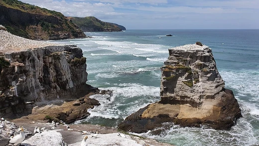
Cabo da Roca
Westernmost point of continental Europe and the Eurasian landmass.

Cabo da Roca, also known as Cape Roca, is a cape that forms the westernmost point of the Sintra Mountain Range, mainland Portugal, continental Europe, and the Eurasian landmass. Known to the Romans as Promontorium Magnum and during the Age of Sail as the Rock of Lisbon, the cape is within the Sintra-Cascais Natural Park.
- location
- Sintra municipality, near Azóia, west of Lisbon, Portugal
- coordinates
- 38°47′N 9°30′W
- elevation
- Cliffs more than 100 metres in height
- field
- Geography
- known_for
- Westernmost point of continental Europe and the Eurasian landmass
Lore & Background
Cabo da Roca was known to the Romans as Promontorium Magnum and during the Age of Sail as the Rock of Lisbon. The cape is within the Sintra-Cascais Natural Park, 42 kilometres west of Lisbon. A stone plaque at the site inscribes the location coordinates 38°47′N 9°30′W. The western coast features a mixture of sandy beaches and rocky cliff promontories, with cliffs over 100 metres in height cut into crystalline rocks composed of strongly folded and faulted sedimentary units, disturbed by dikes and small beaches. The promontory is the extreme western immersion of the ancient eruptive Sintra massif, evident from rose-coloured granite in the north and syenite in the south. Nearby geomorphological examples include gabbro-diorite, volcanic breccia, and granite. Some granite formations show evidence of strong coastal erosion, while other areas have limestone deposits embedded in the granite.
Reader's Guide
Cabo da Roca holds significance as the westernmost point of mainland Portugal, continental Europe, and the Eurasian landmass, marking a geographic extreme of the European continent. The cape's geology, including crystalline rocks, granite, and volcanic breccia, reflects complex tectonic and erosional history. The site is also notable for ecological changes: native low-lying vegetation adapted to saltwater and wind has been largely overrun by the invasive species Carpobrotus edulis, a succulent introduced as ground cover decades ago. The cliffs and coves provide temporary roosting for migratory and marine birds. The climate is extremely moderated by the ocean, with cool, stable summers featuring frequent fog and high humidity, and rainy winters with mild temperatures. Summer is the windiest season, and due to seasonal lag, September is warmer than July. The cape remains a landmark for geography and natural history.
Did You Know?
- Cabo da Roca was known to the Romans as Promontorium Magnum.
- The invasive plant species Carpobrotus edulis now covers much of the arable land on the cape.
- Due to seasonal lag, September is warmer than July at Cabo da Roca.
Frequently Asked Questions
What is Cabo da Roca?
Cabo da Roca is a cape at the western end of the Sintra Mountain Range, situated in the municipality of Sintra near Azóia, west of Lisbon, Portugal. It falls within the Sintra-Cascais Natural Park.
Why is Cabo da Roca geographically significant?
It is recognized as the westernmost point of mainland Portugal, continental Europe, and the entire Eurasian landmass, sitting at roughly 38°47′N 9°30′W.
What historical names has Cabo da Roca gone by?
Roman sources referred to it as Promontorium Magnum, while mariners of the Age of Sail knew the headland as the Rock of Lisbon.
How tall are the cliffs at Cabo da Roca?
The sea cliffs at the cape rise to more than 100 metres above the ocean, making it one of the most dramatic coastal drop-offs in western Europe.
More in Coastal And Marine Features 1-24
Spotted an error? Know more?
This is a living reference — every entry is fact-audited, and reader corrections feed straight into our audit queue. Suggest an edit · See this site's audit record