Cape Breton Island
Island forming part of Nova Scotia, Canada, with a history of coal mining and French fortifications.

Cape Breton Island is the largest offshore island forming the bulk of the eastern part of the province of Nova Scotia. It is notable for its mining industry, particularly the coal that was discovered in rocks and cliffs by explorers and settlers in the 17th and 18th centuries. Coal was used to heat houses and factories, used by blacksmiths to mold iron, and for the steam engines of trains. Coal was extracted principally in the Sydney–Glace Bay area until the mines were closed in 2001. Many mines have shut down as coal becomes a less popular fuel, though Nova Scotia still gets most of its electricity from coal, most of which is now imported. Some of Cape Breton's mines have been turned into tourist attractions and museums, with retired miners taking people on tours of old mines.
- population_change_2011_2021
- -0.83%
- percentage_of_Nova_Scotia_population
- 13.9%
Lore & Background
Cape Breton Island was once attached to Scandinavia and Scotland as part of the Avalon terrane, before continental drift joined it to present-day North America. The French maintained control of Cape Breton Island (which they called Île Royale) after the Treaty of Utrecht in 1713, while Britain gained control of present-day peninsular Nova Scotia. The largest defensive installation in Nova Scotia was a French military fortified port at Louisbourg Harbour on Cape Breton Island. The fortified military port of Halifax on Halifax Harbour was founded to counter Louisbourg's presence. Cape Breton Island was created as a separate colony in 1784 to accommodate United Empire Loyalist refugees, but in 1820 it was permanently folded back into Nova Scotia, resulting in the present-day provincial territory. The Bras d'Or Lake, a 1,100 square kilometres (420 sq mi) estuary, defines the central portion of Cape Breton Island.
Reader's Guide
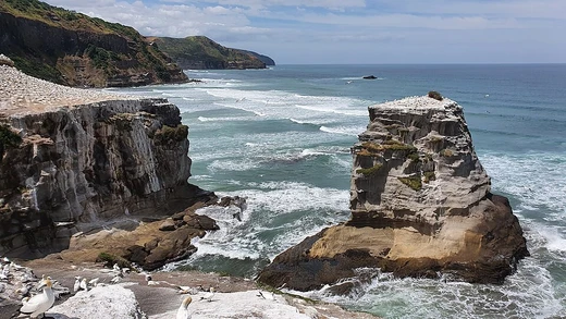
Visitors to Cape Breton Island can explore the legacy of its coal mining industry, which was concentrated in the Sydney–Glace Bay area. Many mines have been turned into tourist attractions and museums, where retired miners lead tours of old mines. The island also features the historic French fortified port at Louisbourg Harbour, the largest defensive installation established along Nova Scotia's coastal settlements. The Cabot Strait lies north and east of Cape Breton Island, and the island's southern and eastern parts constitute a pelagic coast fronting the open Atlantic Ocean. The Bras d'Or Lake, a large estuary at the centre of the island, offers a unique inland waterway. The island's rugged terrain and coastal landforms, shaped by glaciation and rising sea levels, provide a varied landscape from rocky shores to sandy beaches.
Did You Know?
- Cape Breton Island was once attached to Scandinavia and Scotland as part of the Avalon terrane.
- The French called Cape Breton Island 'Île Royale' after the Treaty of Utrecht in 1713.
- The largest defensive installation in Nova Scotia was a French military fortified port at Louisbourg Harbour on Cape Breton Island.
- Coal was extracted principally in the Sydney–Glace Bay area of Cape Breton Island until the mines were closed in 2001.
- The Bras d'Or Lake is a 1,100 square kilometres (420 sq mi) estuary that defines the central portion of Cape Breton Island.
Frequently Asked Questions
What is Cape Breton Island?
Cape Breton Island is a rugged, irregularly shaped island on the Atlantic coast of North America that forms part of the Canadian province of Nova Scotia. It accounts for roughly 18.7% of Nova Scotia's total land area and is defined by its dramatic coastal and marine geography.
How is Cape Breton Island connected to the mainland?
The island is linked to the Nova Scotia mainland by the Canso Causeway, a road bridge that spans the Canso Strait. This single connection point governs all vehicular traffic between the island and the rest of the province.
What is Cape Breton Island's population and how has it changed?
The 2021 census recorded 134,850 residents on the island, representing about 13.9% of Nova Scotia's total population. The figure reflects a slight decline of 0.83% compared with the 2011 count, and roughly three-quarters of islanders live within the Cape Breton Regional Municipality.
What is Cape Breton Island's historical significance?
The island carries a deep layered heritage shaped by Mi'kmaq Indigenous peoples and later European settlers across many centuries. Its Atlantic coastline and marine features have long driven the cultural, economic, and social life of its communities.
Why is Cape Breton Island important to Nova Scotia?
As a geographic and cultural anchor that contributes nearly a fifth of the province's total area, the island is central to Nova Scotia's identity. Its rugged Atlantic shoreline, rich marine environment, and centuries-old history make it a defining feature of the region.
More in Coastal And Marine Features 1-24
Spotted an error? Know more?
This is a living reference — every entry is fact-audited, and reader corrections feed straight into our audit queue. Suggest an edit · See this site's audit record