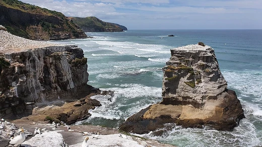
Cape Lopatka
Southernmost point of Kamchatka, site of a 64 m tsunami.

Cape Lopatka is the southernmost point of the Kamchatka Peninsula in Russia.
- location
- Southernmost point of Kamchatka Peninsula, Russia
- coordinates
- Approximately 11 km north of Shumshu, Kuril Islands
- earthquake_magnitude
- 9.0–9.3 MW
- climate_type
- Polar (Köppen Dfc/ET)
- mean_annual_temperature
- 2.0 °C (35.6 °F)
Lore & Background
Cape Lopatka lies at the southern tip of the Kamchatka Peninsula, with the rural locality of Semenovka at its southernmost point. It is situated about 11 km north of Shumshu, the northernmost island of the Kuril Islands. The cape also marks the northernmost area of habitation by the Ainu people.
Reader's Guide
Cape Lopatka holds significance as a geographic landmark and a site of extreme natural events. The cape is also notable as the northernmost area where the Ainu people have lived. Winters are moderately severe, with no permafrost, and temperatures have never fallen below −21.0 °C. The extreme winds make it feel much colder. These factors make Cape Lopatka a unique location for studying climate extremes and tsunami risks.
Did You Know?
- Cape Lopatka is the southernmost point of the Kamchatka Peninsula, Russia.
- It is the northernmost area of habitation by the Ainu people.
Geographic Role in Defining the Sea of Okhotsk
Cape Lopatka, identified as the southern point of the Kamchatka Peninsula, serves as a critical reference in the International Hydrographic Organization's formal delineation of the Sea of Okhotsk's southeastern boundary. The IHO specifies that this limit follows a line extending from Nosyappu Saki (Cape Noshap) at 43°23'N on the island of Hokkaido, passing through the chain of Kuril or Tisima Islands, and terminating at Cape Lopatka. The boundary is drawn with the explicit purpose of encompassing all the narrow waters lying between Hokkaido and Kamchatka within the Sea of Okhotsk. The Kamchatka Peninsula, of which Cape Lopatka forms the southern extremity, constitutes the eastern edge of this marginal sea of the northwestern Pacific. With the exception of Hokkaido, the entire perimeter of the Sea of Okhotsk is bordered by territory under Russian Federation administration, placing Cape Lopatka firmly within Russia's maritime domain.
Climate of the Surrounding Waters
The waters adjacent to Cape Lopatka belong to the Sea of Okhotsk, which holds the distinction of being the coldest sea in East Asia and the southernmost sea in the Northern Hemisphere to experience seasonal freeze-over. The regional climate is dominated by the interplay between two major atmospheric pressure systems: the Siberian High pressing down over the Asian continent and the Aleutian Low hovering over the North Pacific. When the Aleutian Low shifts northward from its mean position near Kamchatka, cold northerly outbreaks intensify and ice cover becomes heavier. In the northeastern part of the sea, mean February air temperatures reach approximately −20 °C, while the coldest months are January and February. From October through April, the northern reaches of the sea are largely ice-covered and receive little precipitation. The sea's subarctic maritime climate means that winter conditions in its northern and western approaches approach those of the Arctic itself.
Oceanographic Processes and Circulation
The Sea of Okhotsk, whose southeastern boundary terminates at Cape Lopatka on Kamchatka, exhibits a pronounced cyclonic—counter-clockwise—circulation pattern driven by prevailing winds. A defining oceanographic feature of this sea is its cold intermediate, or dicothermal, layer: a residual band of frigid water whose core hovers near −2 °C and which can persist throughout the entire warm season beneath the seasonally warmed surface layer. This creates a sharp temperature gradient between surface and subsurface waters. In winter, surface water across much of the sea drops to near its freezing point of roughly −1.8 to −2 °C. The overall circulation, combined with the formation of Dense Shelf Water through brine rejection during ice formation on the northwestern shelf, ventilates the North Pacific Intermediate Water and carries oxygen and nutrients into the wider ocean. Deeper water averages about −1.8 to −1 °C, while surface salinity remains comparatively low at around 32.5 parts per thousand or less due to river discharge.
Environmental Change and Regional Significance
The Sea of Okhotsk, bounded at its southeastern extremity by Cape Lopatka on Kamchatka, has experienced warming in some areas of as much as 3 °C since preindustrial times—three times the global mean rate. This warming inhibits sea ice formation and drives fish populations northward. The salmon catch along the northern Japanese coast has declined by 70% over the last 15 years, while the Russian chum salmon catch has quadrupled in the same period. Long-term observations reveal a marked reduction in winter ice extent since the late 1980s, associated with a weakening of the regional pressure gradient between the Siberian High and the Aleutian Low. Modelling links the resulting larger open-water fetch to increasing winter wave power over the sea. The intermediate layer has also warmed over recent decades, accompanied by a decline in dissolved oxygen that points to a reduction in the formation of the cold intermediate layer. Politically, the sea is surrounded, save for Hokkaido, by Russian territory, with Japan maintaining claims over the southern Kuril Islands, which it designates as the Northern Territories.
Frequently Asked Questions
What is Cape Lopatka and where is it located?
Cape Lopatka is the southernmost tip of the Kamchatka Peninsula in Russia, sitting roughly 11 km north of Shumshu in the Kuril Islands chain. It marks the point where the peninsula's coastline meets the Sea of Okhotsk.
What caused the devastating 1737 tsunami at Cape Lopatka?
A powerful earthquake estimated at 9.0–9.3 on the moment magnitude scale ruptured the seafloor offshore, displacing a column of water that generated the record-breaking wave.
What kind of climate does Cape Lopatka experience?
The cape sits in a polar climate zone (Köppen Dfc/ET), with a mean annual temperature of just 2.0 °C (35.6 °F) and long, cold winters typical of high-latitude coastal Russia.
Why is Cape Lopatka historically significant beyond its geology?
The area is recognised as the northernmost region where the Ainu people maintained a presence, giving the cape a unique place in the cultural history of the far northeast.
More in Coastal And Marine Features 1-24
Spotted an error? Know more?
This is a living reference — every entry is fact-audited, and reader corrections feed straight into our audit queue. Suggest an edit · See this site's audit record