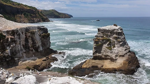
Cape Fear (headland)
Headland on North Carolina coast, site of historic landfalls.

Cape Fear is a prominent headland jutting into the Atlantic Ocean from Bald Head Island on the coast of North Carolina in the Southeastern United States. It is largely formed of barrier beaches and the silty outwash of the Cape Fear River, and acts as a breakpoint for tropical cyclone warnings and watches issued by the National Hurricane Center.
- location
- Bald Head Island, North Carolina, Southeastern United States
- type
- Headland
- formed_by
- Barrier beaches and silty outwash of the Cape Fear River
- drainage
- Largest watershed in North Carolina, containing 27% of the state's population
Lore & Background
Sailing to Roanoke Island, his ship became embayed behind the cape, and some of the crew were afraid they would wreck, giving rise to the name Cape Fear. It is the fifth-oldest surviving English place name in the U.S. The headland is formed by the intersection of two sweeping arcs of shifting, low-lying beach, the result of longshore currents which also form the treacherous, shifting Frying Pan Shoals, part of the Graveyard of the Atlantic. Dunes dominated by sea oats occur from the upper beach drift line back to the stable secondary dunes, where they mix with other grasses and herbs to form a stable salt-tolerant grassland. The Cape Fear estuary drains the largest watershed in North Carolina, containing 27% of the state's population.
Reader's Guide
Cape Fear holds significance as a landmark of early European exploration and colonial history in North America. Geologically, Cape Fear is a dynamic feature shaped by longshore currents and river outwash, creating the hazardous Frying Pan Shoals. Its ecological role includes supporting salt-tolerant grasslands and serving as a drainage basin for the largest watershed in North Carolina. The cape also functions as a critical breakpoint for tropical cyclone warnings, underscoring its ongoing importance to maritime safety and weather monitoring.
Did You Know?
- Cape Fear is the fifth-oldest surviving English place name in the United States.
- The treacherous Frying Pan Shoals, part of the Graveyard of the Atlantic, are formed by longshore currents near Cape Fear.
- Cape Fear acts as a breakpoint for tropical cyclone warnings and watches issued by the National Hurricane Center.
The Passage That Changed the World
In 1433, Portuguese mariner Gil Eanes set out to round Cape Bojador and failed. The following year, acting on the direct orders of Prince Henry the Navigator, he returned and succeeded. This second attempt in 1434 proved to be a watershed moment for European maritime history, opening a viable sea route toward the African coast and, ultimately, toward India. Before Eanes' achievement, the cape had earned a terrifying reputation among sailors. Ships that had tried to pass it in earlier decades simply vanished, and the violent seas around the headland fueled rumors of sea monsters lurking beyond the horizon. The prevailing belief was that the ocean itself was on fire past the cape, a supernatural barrier that no human vessel could cross. Henry's men proved otherwise, and in doing so they shattered a psychological wall that had held back European exploration for generations. The success of this modest headland passage set in motion the chain of voyages that would reshape global trade and geopolitics.
Poetry and the Boiling Sea
The psychological terror that Cape Bojador inspired found one of its most enduring expressions in the poetry of Fernando Pessoa. In his early twentieth-century work Mensagem, Pessoa captured the mythic weight the cape held for Portugal, writing that whoever wished to pass beyond Bojador must also pass beyond pain. The imagery of a sea set ablaze beyond the headland was not mere fancy. Sailors who witnessed the waters around the cape reported seeing the ocean bubble and hiss as though it were literally boiling, a phenomenon caused by shoals of sardines rising to the surface during feeding times, their tails flicking against the water and producing a distinctive hissing sound. The desert heat blowing in from the west, combined with dust that created an eerie darkness, amplified the illusion of extreme temperature. Even compass needles spun erratically over the ferrous rocks near the shore. These very phenomena, which medieval mariners interpreted as evidence of supernatural danger, remain observable today, and modern vessels still give the area a wide berth.
The Hidden Reef and Shifting Winds
On a chart, Cape Bojador looks unremarkable—a low point on the southwestern edge of a slight coastal hump, bounded ten nautical miles to the northeast by Cabo Falso Bojador. Yet the true danger lies beneath the surface. The cape extends into the sea as an underwater reef, and within roughly three miles of the coast the water is no deeper than six feet. When waves crash into unseen gullies, the water erupts into towering clouds of foam that resemble steam, even on perfectly calm days. Beyond the reef, the real threat is meteorological: at the latitude of the cape, winds shift to blow strongly from the northeast in every season. Combined with a half-knot current setting down the coast, these conditions would have terrified a medieval sailor navigating close to shore with no idea what lay ahead. The solution, eventually discovered, was to sail far out to sea, beyond the sight of land, where more favorable winds could be caught. Between 1790 and 1806 alone, at least thirty shipwrecks were recorded in the area.
A Coast That Defies the Map
The physical geography around Cape Bojador resists accurate cartography. Dean King, in his book Skeletons on the Zahara, notes that any coastal map of Western Sahara is unreliable because the harsh desert conditions cause the shoreline features to shift constantly. The water's depth is deceptively shallow, and the sand beneath the surface presents what King calls a fearful sight. As recently as 2004, the British Royal Navy's Africa Pilot cautioned that nautical charts of this stretch of coastline were reported to be inaccurate. The cape's danger is not merely historical; it remains a live navigational hazard. The area also supports abundant marine life, with sardines and other fish drawing larger predators, and Spanish fishing fleets have long operated from the Canary Islands along this desert coast. The headland gives its name to the nearby town of Boujdour, home to roughly 42,651 people, and to the surrounding province. Its Arabic name, Abu Khaṭar, translates to father of danger—a fitting epithet for a place that has swallowed ships and inspired poets for centuries.
Frequently Asked Questions
What is Cape Fear (headland)?
Cape Fear is a prominent headland that extends into the Atlantic Ocean from Bald Head Island along North Carolina's southeastern coastline. It is composed mainly of barrier beach material and silty sediment deposited by the Cape Fear River.
How was Cape Fear (headland) formed?
The headland was shaped by the accumulation of barrier beach material combined with silty outwash carried out by the Cape Fear River. Together these processes built up the landform that juts into the Atlantic.
Why does Cape Fear (headland) matter for hurricane tracking?
The National Hurricane Center designates Cape Fear as a breakpoint when issuing tropical cyclone warnings and watches along the Southeast coast. Storms are therefore tracked relative to this point when determining which areas face the greatest threat.
How significant is the watershed associated with Cape Fear (headland)?
The Cape Fear River system drains the largest watershed in all of North Carolina. That basin is home to roughly 27 percent of the state's total population, making it one of the most geographically important features in the region.
More in Coastal And Marine Features 1-24
Spotted an error? Know more?
This is a living reference — every entry is fact-audited, and reader corrections feed straight into our audit queue. Suggest an edit · See this site's audit record